Building Weather Resiliency in Vertiport and Corridor Operations
Summary
Advanced Air Mobility is highly dependent on weather conditions, especially operating in complex urban environments. Existing weather sensing infrastructure is not sufficient to address this challenge.
Advanced Air Mobility (AAM) will revolutionize urban transport, logistics, and commerce by transforming commuter transit and rapid delivery systems. Ensuring safe, sustainable, cost effective, and accessible AAM operations requires accurate weather data and an associated diversification and localization of weather monitoring and prediction systems. Due to the current low operational tempo of vertical take-off and landing (VTOL) operations (i.e. helicopters) in urban contexts, operations have been sufficiently supported through weather information collected via proximate airport based weather reporting infrastructure and on-heliport wind cones. To support a higher operational tempo, airspace users, including UAS operators and eVTOL aircraft will require more thoughtful placement and configuration of vertiports to support high density operations, and higher fidelity microclimate information to support more comprehensive flight planning, risk mitigation, and inflight decision making. Further, testing methods for obtaining higher fidelity microclimate information will support the cost-effective scaling to higher density operations in the future.
Using existing infrastructure, weather conditions are only known where current civil aircrafts are flying, and at low levels of granularity. For example, many cities use sensors located at nearby airports to determine weather conditions. However, in reality, cities are highly complex environments, where weather and especially wind conditions are affected by buildings nearby and vary block by block. This means that with today’s technology, it is difficult to achieve a high level of operability for eVTOLs in cities, and to know whether they can safely fly at a given time and in a given flight corridor. In addition, both of these factors may vary based on the specifications of the eVTOL in question.
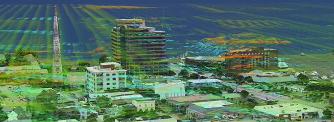
Weather sensors placed in urban environments can provide a vertical 360 view of airflow patterns, and reveal areas compromised by Ventura Effects and eddies around buildings. The orange areas depict high wind speeds AGL (above ground level) and would not be forecasted by local aviation reports or surrounding weather stations without additional sensing instruments.
In order for Advanced Air Mobility to be successful, a detailed analysis of wind and weather conditions is necessary, which can only be achieved by deploying the optimal combination of sensors and models. This means that an appropriate network of sensors must be installed near vertiports and flight corridors, and that advanced wind and weather models must be deployed to make the best use of these sensors and create a granular and full three dimensional weather twin.
Developing AAM and UAM infrastructure with an early consideration of how wind and weather impact areas will contribute to a more predictable, reliable, and safer operational environment. When evaluating wind data in urban areas, it is important to avoid relying only on data produced from ASOS data at the airport. This is because urban wind flows and hazards caused by building obstructions make airport data mostly irrelevant for vertiport placement and airspace routing decision making. The data must be corrected for the impacts of buildings on hyper-local wind flows in and around urban areas.
The Urban Movement Labs, TruWeather Solutions and DM-AirTech have formed a consortium to provide a comprehensive capability to provide weather solutions for Advanced Air Mobility. We have already completed a successful project for the Greater Los Angeles area. During this project, we made recommendations to optimize and augment the existing weather sensor network and determined the best locations for building vertiports based on forecasted operability, and economic factors
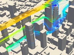
Depiction of Tier-3 analysis using GWC to compute effects of building wakes during the operability forecast assessment on LA downtown rooftops
After performing a global operability forecast for a city or a region and after the economic metrics are validated from various stakeholders, it is necessary to perform a micro weather evaluation of the areas designated as candidates to host infrastructure. This evaluation needs to capture the effects of the built environment on winds, e.g. building wake, canyoning effects, and others, and to:
- Refine the operability forecast. which coupled with other commercial insights allows optimal vertiport locations to be selected.
- Analyse hyperlocal wind effects which will be translated into vertiport design and further weather sensing needs.
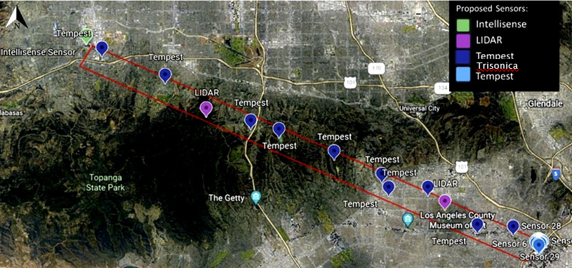
Proposed Sensor locations within the notional flight corridor to meet criteria in Tier 1
Urban Movement Labs is a first-of-its-kind nonprofit collaboration of government, businesses, and the community to design and deploy transportation tech solutions in real urban conditions. Building pathways for emerging transportation technology by supplementing city resources as a trusted third space to rapidly develop policy, and scale data-informed, community-driven and tech-enabled mobility solutions.

DM-AirTech brings a proprietary and unique solution to the Advanced Air Mobility which leverages the latest advancements in physical-based numerical modeling and system engineering to reconstruct weather at the microscale and to transform that reconstruction into actionable data for city and urban planners, OEMs and operators. At the core of DM-AirTech, the GWC system provides the capability to augment weather sensing capabilities. GWC can reconstruct weather and wind patterns in the most complex environments to address the challenges of developing aerial mobility networks and operating eVTOLs.
TruWeather Solutions is a leading innovator in full spectrum low altitude weather data changing the paradigm for how micro-weather is used to optimize UAS and VTOL flight ops. TruWeather is the first weather solution provider to offer an array of web services and custom decision products explicitly built for the low-level airspace. TruWeather’s V360° platform offers current and predictive weather data and visualizations, Go/No Go decision analytics, weather radar, aviation weather reports, Terminal Aerodrome Forecasts, digital weather from camera images, and flight route weather risk profiles.
